
File:SkiLand-1-.jpg
From Helderberg Hilltowns of Albany County, NY
Revision as of 19:52, May 13, 2022 by Maintenance script (talk | contribs) (Maintenance script uploaded File:SkiLand-1-.jpg)
No higher resolution available.
SkiLand-1-.jpg (572 × 442 pixels, file size: 87 KB, MIME type: image/jpeg)
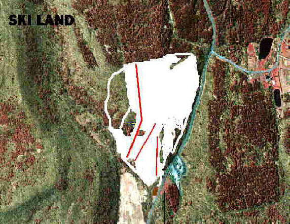
Map of area showing open slopes, trails, and lifts.[1] (South is at the top). The red roofed Ski Lodge is in the lower center below the lowest lift. The parking lot is the open field below the ski slope. Cole Hill Rd. runs up the hill to the south along the right side of the slopes. The blue area to the right of the Rd. is the Road Maintenance Area. At the top of Cole Hill Rd. is the intersection with Willsey Rd. which goes to the west. Filkins Hill is to the left of the photo.
File history
Click on a date/time to view the file as it appeared at that time.
| Date/Time | Thumbnail | Dimensions | User | Comment | |
|---|---|---|---|---|---|
| current | 19:52, May 13, 2022 | | 572 × 442 (87 KB) | Maintenance script (talk | contribs) | == Summary == Importing file |
You cannot overwrite this file.
File usage
The following page uses this file:
